02.11.2016 by Infogram
We are all used to reading maps, but chances are you’ve never seen maps like these. Maps, like most data visualizations, display data in a fun and interesting way, revealing trends and surprising insights.
We’ve collected ten mind-blowing maps that will change the way you view the world:
1) The True Size of Africa
Who knew Africa was so big? Kai Krause, a computer-graphics guru, caused a stir online after posting this map showing the outlines of other countries crammed into the outline of the African continent.

2) Rising Seas: If All the Ice Melted
The maps here show the world as it is now, with only one difference: All the ice on land has melted and drained into the sea, raising it 216 feet and creating new shorelines for our continents and inland seas.

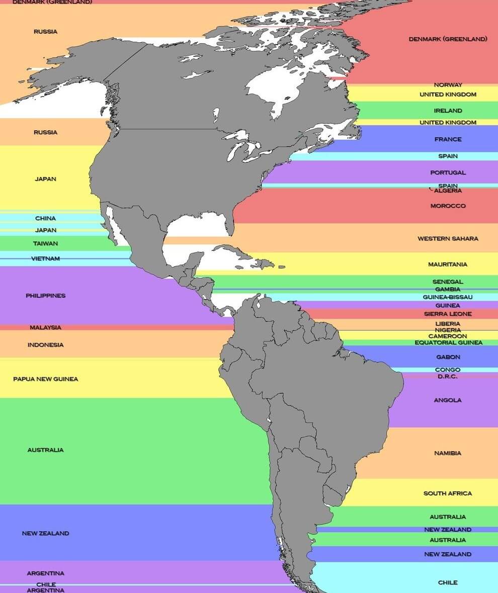
3) What’s Across the Ocean
Have you ever stood on the beach and wondered what was across the ocean? This map shows the countries that are due east and west from points along the coasts of North and South America.
4) Flight Patterns
When you’re flying, it’s easy to forget you’re not the only plane in the sky. View the paths of air traffic over North America visualized in color and form. Watch the amazing video!

5) Common Spoken Languages Other than English or Spanish
The Census Bureau’s American Community Survey includes a detailed look at the languages spoken in American homes. Slate visualized the most commonly spoken languages other than English and Spanish.

6) Pangea with Modern Borders
This is crazy! It’s a map of Pangea, the supercontinent that formed around 300 million years ago, mapped with contemporary geopolitical borders.

7) Walmart Growth Map
Watch the growth of Walmart and Sam’s Club starting in 1970. The bubbles pop up so quickly it looks like a spreading wildfire!

8) Population Circle
The map below shows one the craziest facts about the world: there are more people living inside the circle than outside of it.

9) Upside Down Map
Have you ever seen the world like this? South-up map orientation is quite a trip. It involves an 180-degree rotation of the standard north-up map convention. They are sometimes called upside down maps or reversed maps.

10) Global Shipping
This fun interactive map offers a few different views with animated dots to represent moving ships, paths to show routes all at once, and filters to focus on areas of interest.

Do you have geographical data you’d like to visualize? Infogram has over 200+ regional maps for you to choose from! You can share your data as a heatmap, colorful watercolor, create tile layers, or hand-pick a color palette of your own.

Get data visualization tips every week:
New features, special offers, and exciting news about the world of data visualization.